
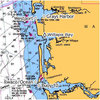
Westport to the Columbia
Fishing the open ocean off of Ilwaco, Westport, La Push, and Neah Bay is fun and exciting, and often very, very productive. The difference in the number of fish caught in Puget Sound and the number of fish caught off the coast is amazing. The weather off the coast can be harsh and unpredictable in the spring, so the fishing out here is done primarily in the summer. Select a region to learn more:
Lower Columbia / Buoy 10
There is an agreement between the two states called shared jurisdiction. What this means is that a Washington angler can fish in a BOAT in Oregon waters, and the other way around. You can also launch on either shore & fish, with either license. HOWEVER, you CANNOT bank fish on a shore that you are NOT licensed for.
 Washington & now Oregon have fishing regulations in effect on the river as described by the new Oregon regulations. “Each angler aboard a vessel may continue to use angler gear until the daily limit of fish for all legally licensed & juvenile anglers aboard has been achieved. However no individual angler may exceed any personal daily bag limit.”
Weather Conditions:
The weather here can at times be windy & therefore choppy enough that the average small boater should be very observant. If you are on the middle of the river & the wind comes up, it will behoove you to move closer to your launch point before it gets dangerously rough.
The wind typically picks up between 1:00 & 3:00pm and there WILL be chop on the water when you head back if you launch at any of the first two launches listed below. With a smaller or an open boat you WILL get wet. This wind usually dies down later in the evening, usually around 7:00pm.
A deep 16′ boat would be considered minimal, and it should be mandatory that an operational bilge pump and a fully functioning kicker motor be attached & ready. A convertible top can be a lot of help if you are running with any chop on the water.
Water Conditions:
This is a large river with LOTS of water moving during any exchange. A small skipper miscalculation or inattention for a moment could be deadly. It is prudent to have all on board wear a Personal Floatation Device. The new suspender inflatable type are becoming more popular since the Coast Guard has now approved them, (if being worn).
Commercial Vessel Traffic:
One thing to keep in mind is that this whole river is a means of commercial water travel for many different types of vessels, including ocean going ships & tugs. The normal shipping lane depths may be dredged & kept at a minimum of 40ft. The ships will be coming in at any time of tide but upriver & downriver traffic can increase during the high tide. These shipping lanes are just like a highway, with upriver designated for the Oregon side, & downriver designated for the Washington side of the lane.
If you as a small boater plan on fishing & or anchoring near these shipping lanes, it may be a good idea to become familiar with the US Coast Guard “Rules of the Road” as far as who has right of way & the boat whistles governing them.
Method of Fishing:
Most of this salmon fishing will be trolling a cut-plug herring off a diver trolled with from 25′ to 40′ of line out. The use of a Fish Flash no-drag flasher has now become widespread. When using it behind a diver, you may need to tie a short length of line (12″) between the diver & the Fish Flash to allow it to get out of the diver’s turbulence so that the Flash will rotate properly.
An Apex plug in chrome, blue prism/chrome or a Coyote spoon in cop car, or glo in the dark green/white can also be very productive here using the diver, or off a downrigger if you are fishing an area that is out of the heavy concentration of boats.
Mooching a cut-plug herring is of course another viable method practiced by some.
Where to fish:
Close to Buoy 10 can be called “Combat Fishery”, meaning the boats will be maneuvering, trolling/mooching in close proximity to each other, and some boat operators do not watch where they are going. Charter boats seem to tend to squeeze the sport boats, with their rods almost touching the smaller boats. Other boaters may seem to not be aware of what is going on around them, as when a big fish is being played within 20′ of their boat. This can be compared to a large dance with MOST of the boats all hopefully going the same large circle & close to each other. Occasionally a blind operator may want to troll across through the trollers or a mooching dance floor, which may even get more than under the breath exclamations toward him. It is not uncommon to look out & see 300+ boats in an area of 1/2 mile. One thing, if anyone fell overboard, they would not be in the water for over a few minutes.
Most salmon fishing early in the season will be near Buoy 10 at low incoming tide, some prefer just north while others prefer south of the buoy. When fishing for Chinook early in the season, a trend is to be at the buoy at low incoming tide & allow the tide to carry you upriver along the Oregon side, sliding across & over to the Washington side just above Chinook. There seem to be good bait holding spots off the breakwater piling on the Washington side near both Big & Little Sand Islands on the high ebb.
When the Coho are in, they of course will be intercepted first at the buoy “Firing Line”, then they follow a rip upriver as the tide comes in. Later on in the tide & or season, the fish seem to congregate near the northern end of the Astoria/Megler bridge.
 The worst, as far as concentration of boats, will be near Buoy #10, which is the westernmost WDFW /ODFW boundary & the first shot at these returning fish. It seems to be human nature to be there at the starting gates when the gun goes off. The jetties’ shore ends, would be about between buoy #11 on the north & buoy #12 on the south. Buoy #10 is located about 1 mile outside or west of these two buoys. This area, however, seems to be one of the best locations to fill a limit. Most of the charter boats will work this area.
Many people will bypass the buoy & fish upriver near the middle of the river and near where the “Yellow Can” (D) buoy, N46°14’40” W123°57’30”, used to be, (they have removed it in the last couple of years). It still shows on some older charts, which designates a dredge dumping area and is in 25-30′. It is about 1/2 mile off the breakwater near the town of Chinook entrance.
There is also a 50’/60′ slot at the “Church Hole” which is between the Chinook entrance & upriver to the bridge on the Washington side, where many Chinook salmon are taken. There is an old church on the Washington shore that is right on the shore & it’s steeple is very visible, hence the name. The charts may only say “Spire” on the shore in this location. The other area where many fish are taken is again from the church to the bridge but farther away from shore in the 30′ slot. As the tide nears & goes into high slack, the fish then seem to congregate above the bridge & up to the WDOT rest area. This area near the Washington shore has also been called the “Blind Channel”
Some nice Chinook have been pulled by back bouncing a herring along the bottom thru this Church Hole slot on an outgoing tide.
There seems to be an imaginary line from the Washington side high spanned section of the bridge to Tongue Point that the upriver salmon seem to follow and cross over the shallows at high tide to the main channel on the Oregon side. The few that stay near the Washington shore in the upper end of the bay, will probably be Deep River or Grays River fish.
The rivers deeper channel splits at about the Chinook entrance. It is wide & deep enough at this area that many fishermen do not realize this split takes place. The main shipping channel follows the Oregon shore up past Astoria, Tongue Point & on east of Rice Island & then onward toward Cathlamet. The center of the river below & above the bridge is dotted with sand spits at low tide.
The deeper water on the Washington side terminates above the bridge just above the WDOT rest area. This channe lis sometimes called the “Blind Channel”. This shallower channel then runs upriver toward Portuguese Point & then on into the mouth of Deep River & Grays River.
The water temperature recorded at Bonneville Dam this time of the year usually will be 70 to 72 degrees, but on the incoming tide at Illwaco, the cooler (56 degree) ocean water will come in & back upriver on the high tide, cooling the river water to below 60. As the tide turns and starts running back out the temperature will raise to about 62-65 degrees. Once the fish move above this cooler water where there isn’t the cooler salt mix, this is really warmer for them to comfortably stay in. So the early fall Chinook above this estuary will more than likely then be found in the deeper holes or at the mouths of the rivers dumping into the Columbia.
Boat Launches:
There are many launches on both the Washington & Oregon side of the river in this vacinity.
Illwaco: Port of Illwaco 165 Howerton Ave., Illwaco, WA 98624, 360-642-3143, $5.00
Fort Canby (State Park) $5.00
Chinook: Port of Chinook, 1 Portland St., Chinook, WA 98614, 360-777-8797, $5.00
Deep River: Eva’s Bait & Tackle, 121 Onieda Rd., Naselle, WA 98638, 360-465-2582, $5.00
Cathlamet: Elochoman Marina, P.O. Box 651, Cathlamet, WA 98612, 360-795-3501, $3.00
Hammond: Hammond Marina, 1099 Iredale St., Hammond, OR 97121, 503-861-319, $5.00, with a parking fee of $5.00
Warrenton: Warrenton Marina, 550 NE Harbor Pl., Warrenton, OR 97146, 503-861-3822, harbormaster’s cell 503-791-1925, launch fee $5.00
Skipanon Marina: Skipanon Marina, 200 NE Skipanon Drive, Warrenton, OR 97146, 503-861-0362
Youngs Bay Yacht Club: Youngs Bay Park, Astoria, OR, 503-325-7275, free
John Day River, (Tongue Pt., county launch), $3.00
The launch at Illwaco is off the main road into town just after you drop down off the hill, take a left at the sign that says launching ramp. If you miss that, then just go to the stop light, turn left and the frontage road at the dock area, follow it to the eastern end & around the boat basin to the launch on the southeast side. There is a nice new two lane ramp, also a sling, & with lots of paved parking. For Fort Canby, you have to go east thru the town of Illwaco, at the stop light, west & south & then back east, winding thru the park then down to the ramp. The State Parks Dept. is planning to improve this launch in the early summer of 2003. The plans are to install a 3rd lane & to increase parking. The Chinook launch is off Portland Street. It has a new concrete ramp and a sling, but parking is limited & the overflow is along the streets. Also the channel out of the Chinook harbor is narrow & somewhat winding on a LOW tide. There are however small hemlock poles pushed into the edge of the channel.
Bait:
Bait is available at both Illwaco or Chinook thru Ed’s bait. The Illwaco location is open at 5:00am & is on a dock that is close to the launch area. The Chinook location is out of a small grocery store on the west side of the main road north of the launch road. It is the Chinook Country Store, phone 360-777-2248, you can call ahead before closing time which is around 7:30pm & reserve bait for the next day.
The other alternative is Deep River.
It takes about 30 minutes for the average boat to run from this launch downriver to the Astoria bridge. This launch is located off State Highway 4 between Naselle & Cathlamet. If you are coming from Longview on Highway 4, you would go thru Cathlamet, Skamokawa, up over a large hill, & there is a community called Rosburg. The next river you cross will be Deep River, this is a low concrete bridge. This is 25 miles from Cathlamet. TAKE A LEFT AT THE WEST END OF THE BRIDGE ONTO ONIEDA RD.
The pay/bait shack is on the top of a hill a couple of miles south of the highway & before you get to the ramp area. Launch fee is $5 and camping is $10, or $13 with power. Eva, the lady that runs it, makes a trip to Chinook every morning & has fresh bait at about 5:30am during the season. This is a private blacktop ramp, small loading dock, & a reasonable parking lot. But a large mowed field behind the dike road is an overflow lot of about 5 acres with room for dry camping.
This launch is popular with sturgeon fishermen as well as salmon fishermen & this time of the year you may have to wait to launch or load at the prime times. There is not enough dock area (only 2 to 3 boats) to tie up to & then only for launching & loading purposes. You would have to load your boat back on the trailer if you were going to stay overnight. They do not allow power loading because the rock off the end of the ramp can be washed out. There are Sanicans for restrooms here. A fish cleaning station is also provided.
The one drawback here is at a LOW minus tide, the channel as you enter the bay is navigable, but narrow by some standards. There are three deadhead logs that have one end floating, but they appear to not be submerged at high tide & are always showing. One is near #16 in the center of the channel & the others are between Rocky Pt & Portuguese Point in more open water.
The piling markers for the Deep River channel seem to use their own numbers, & after you get in the bay some of these numbers may be repeated.
When you run out of the river from the launch & enter the bay you need to follow the piling markers close, stay on the right hand side going out, water depth will be between 6′ & 9′ on a normal low tide. These markers are all within sight of each other (150 yds) unless you get fog, which may be occasionally in the mornings. The 1st piling out will be #16, then #14, & then #12. From here you start into a right hand corner to #10. Between #10 & #8 is where it is sanded in. If you swing toward the RH shore from #12 to loop around #10, then toward #8, staying to its right, you will be in deep enough water to travel. Now from here you can follow the RH shore piling on down to Rocky Point. Do not hold tight to the shore marker here, as it sits on a rock outcropping near shore. Make another right hand corner beyond the point & head Southwest for about 500yd to within 100yd of that shore. You will turn to the left & head South keeping the shore on your right, heading toward but keeping west of piling marker #14A, which is about 150 yards off the shore.
GPS readings for the marker piling for the Deep River channel are as follows:
|
The point of land here is Portuguese Point, a flat grassy area with the #14A off shore on one side & #13 around the corner next to the shore. A different piling marker #12 is out away from the shore & downstream. Around here is where some sturgeon fishing usually takes place. There is a 90′ hole off the point, most sturgeon are not caught in the hole, but around the edges of it, or into the 14A channel & then down to the #12 piling.
From Portuguese Point, you can see the Astoria bridge, to run to the bridge, head to the north end of it, keeping the WA shore on your right & don’t expect to approach anywhere near the center of the river or cross over if you are using a prop driven boat.
Later when the DFW closes the Buoy 10 area, you will have to fish above Rocky Point on the Washington side to Tongue Point on the Oregon side. The middle of the river above & below the Astoria bridge gets shallow & changes yearly, & at a LOW tide it may have much sand showing, so it is not really practical expect to cross over to fish the main channel above Tongue Point from the Deep River side with a prop boat. Therefore it might be best at that time to launch at Tongue Point or at Cathlamet & run downriver.
The one good thing about this upper area is that if you use it to fish down to, or below the bridge, WHEN the wind picks up in the afternoon below the bridge, you can then slide back upriver toward the launch without bucking any rough water. And as you head back upriver above the bridge the water conditions usually lessen. Then from Portuguese Point to Rocky Point you can drop in & fish for sturgeon if the season is open.
Grays Harbor
While most of the fishing that takes place near the coastal town of Westport is an ocean game, there is another fishery that happens in the fall that can produce some trophy king salmon.

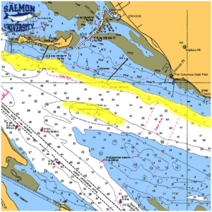
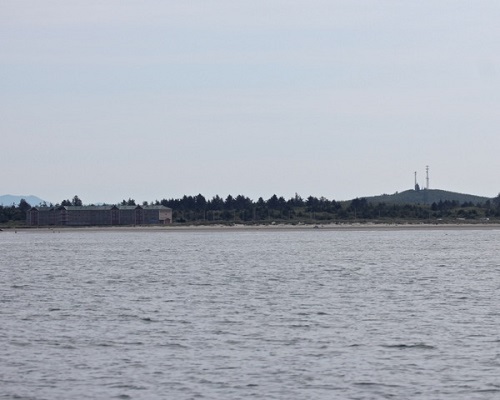
yellow indicates salmon areas
Known affectionately to anglers who fish the place as Johns River, it’s located east of Westport Marine Area 2.2, off the mouth of the Johns River in Grays Harbor. The place should be called the bay of pigs, as thats what your going to catch here in fact it’s one of this state’s last trophy fisheries where you have a chance of nailing a king over 40 pounds.
Why does this tidal area produce such big fish? The Humptulips, Satsop, and Wynoochee rivers all empty into Grays Harbor and they’re all known big fish rivers.
Grays Harbor is the transition zone from salt to fresh water for these salmon heading to the rivers.
Tackle
This is a tide water fishery, meaning leave your downriggers at home, you’re fishing in water that runs 10-30 ft. deep. Most of the fish I catch here are in 15 ft of water or less, many times 8-10 feet.
Large herring are the ticket here, not the Puget Sound size green label, but what we use is purple or black label to score on these fishyes the same size ones you use for halibut.
The normal Johns River setup is a 3 to 6-oz. ball sinker on a 12-inch dropper to a 4-ft. Ande mono leader with 5/0-6/0 hooks. The leader and dropper are mated together to a ball bearing swivel to make the connection.
If I need more attraction then the big herring I will use a Big Als Fish Flash. These pyramid shaped flashers give a great flash in the water and have zero drag in the water. Theyre hard to find in Westport, so stock up before the fishery opens in September.
For a rods, I use a G. Loomis SAR1265C and SAR1084C and a reel with a smooth drag that holds plenty of good 20-25 pound Ande line. Remember these fish can’t sound so they can produce some burning long runs and a cheap reel just won’t cut it here.
Fixed Dropper Setup
There are two basic setups to use… the fixed setup and the sliding setup. On both setups, the first thing to do is remove the front bead chain swivel from the Fish Flash and replace it with a quality ball bearing swivel. For the fixed setup, you then just tie your dropper line to the ring at the front of the swivel, as pictured at the left, and illustrated above. At the bottom end of your dropper, use a regular snap swivel, this will allow you to change weights easily.
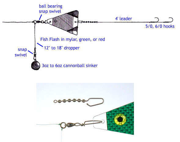
Sliding Dropper Setup
Again, the first thing to do is remove the front bead chain swivel from the Fish Flash and replace it with a quality ball bearing swivel. For the sliding setup, you first hang a bead chain swivel on your mainline, and put a plastic bead below that… the plastic bead protects your knot. This setup is superior to the fixed setup in that if the weight happens to get hung up somehow, like when trying to net a fish, the mainline can still slip through, and the fish can run without breaking your line. Again, use a regular snap swivel on the bottom of your dropper, so you can change weights easily, as shown in the illustration below.

How To Fish Grays Harbor
Most of the fishing takes place in front of the John’s River where it empties into Grays Harbor. There a trough located here where a lot of fish are taken. The bay is pretty featureless so any depression or ledge is worth a look and can hold fish.
The tide is the key factor when fishing here. Tide change is when these fish bite. Sometime just before or after the tide change is when the bite takes place. The rest of the day can be long and slow, with little action happening. This is a quality fishery so dont expect to limit, but it can happen.
Last year during this fishery I would take my charters out over the Westport bar and fish the 12-16 pound coho in the ocean and then run in for the tide change and fish for slabs. The only problem with this plan is getting the clients to leave the coho fishing!
The season here opens Sept 1st, however most of the best fishing is the middle of September to the middle of October. Check the WDFW regulations for current limits and closures.
Boat Launches
There is a boat ramp on the John’s River that is fine for smaller 18 ft boats and jet sleds. It’s located just past the Ocean Spray Company on the highway to Westport. For larger boats, use the ramp in Westport near the Coast Guard Station, it’s a short run back east to the John’s River.
Notes
Pay attention to shipping traffic transiting to Aberdeen and back to the ocean. Stay in the channel especially when running east from Westport. Use the channel markers, there are many sandbars that can ground your boat in this area.
Westport
Fishing out of Westport:
 For people who have never been to Westport, tales of the Chehalis River bar at Grays Harbor can be intimidating, and sometimes rightfully so. For a small boat, a 17’ or 22’ with a V hull, if you watch the weather, time & tides, and use sound judgment, there should be no real problems.
Getting there:
To get to the only launch in the area. As you come into town on Montesano Street, after you pass the airport on the right, at the next intersection will be a Chevron service station. The name of this station is The Hungry Whale. Turn to the east (right) on Wilson Street and the launch is about 2 blocks straight ahead. The trailer parking lot is on the right. The Coast Guard station is between the launch, parking & the water. The launch is owned & maintained by the Port of Grays Harbor. It is a good three lane concrete ramp with loading docks. There however is no freshwater wash down available. Launch fee is $5.00
Bait, both fresh and frozen can be had at the Hungry Whale. However fresh bait has to be reserved by the afternoon the day before you need it. Their phone number is 360-268-0136. One recommendation is if you call the order in, have the person taking the order read it back to you, specifically your name, the DATE WANTED, and the quantity.
Weather:
The weather can be very unpredictable at times. If WDFW gives us an early Chinook season like they have since 2002, you can expect to stay on the beach a few days because of bad weather. As the season progresses, the weather tends to stabilize up until October or so, but the ocean salmon seasons are ended by the end of September.
Fog is often a problem out on the ocean during the summer season. A GPS coupled with a radar unit if you can afford it is highly recommended.
The wind if there is any, will come from offshore & usually from the northwest, but can vary and come from the southwest. If you are trolling, after the wind picks up in the afternoon, it can get hard to control the boat unless you put the wind on your stern. The wind will, on many days pick up & be up to 15mph at about 1:00pm to 2:00pm, and calms in the evening.
If the ocean is rough enough for the Coast Guard to close the bar, you can still fish for bottom fish inside the south jetty. If it is later in the season (the end of July) a few salmon tend to “Dip In” the river mouth with the incoming tide & then are flushed back out with the outgoing tide. You can also fish for salmon inside up to #13 while the ocean is open. The season east of #13 does not open for salmon until September 1.
PFD’s: It is recommended that while under way, especially while crossing ANY bar, that Personal Floatation Devices be worn by ALL on board ANY small craft. The reason for this is that if you get in trouble ON THE BAR and something happens, it will happen so fast that you will not be able to get to, much less even put a life vest on. The new inflatable suspender type PDF’s are comfortable to wear and should accomplish the desired effect.
Heading out:
Leaving the boat basin from the launch, head straight out through the slot in the breakwater piling, then hang a left & head north for the end of the short rock breakwaters at the point. DO NOT GO EAST OF PILING MARKER #7, as it designates the edge of Whitcomb Flats. As you enter the main river off the point, there are a couple of rock breakwaters. Just outside of these, there is a shallow bar of about 15-20 ft in depth and you will encounter a turbulence here for a couple of hundred yards. Once you get beyond this bar, the main river deepens and the water flattens out. There is a small red can buoy “4 T” in the middle of the exit channel. Head toward the “4 T” buoy, then turn to the west and head out the main river.
It is suggested that after you enter the main river & can see west with the south jetty on your left in the distance, head straight out the southern middle of the river to #11, the next one will then be #9. This #9 buoy is beyond the end of the south jetty by about half a mile. If you are going to encounter any roughness it will be in the area of this #9 buoy to beyond #8, which is about 500 yards. From #9 you want to head toward #8. Depending on the currents & roughness off the old submerged jetty (do not cross the submerged jetty it can be extremely dangerous), you may have to hold slightly north of it. When you get beyond the old jetty turbulence, you then can head close to either side of #8. At #8 you can immediately swing to the left & head southwest toward #6. Buoy #8 & buoy #6 are fairly close together. After you head toward #6 you will usually be beyond any bar wave conditions.
The distance from the launch to buoy #8 is about 5.5 miles. From the end of the existing South Jetty to buoy #8 is about 1.5 miles. Buoy #8 is about equal in a westerly direction as the end of the North Jetty.
Crossing the bar:
The one thing that will get you in more trouble than any other thing is SPEED. This is not a boat race. Hold your speed down if it is rough, and then cut the throttle as you ride over a crest so that you do not slam the boat into a trough on the backside of a crest.
On this river, like most rivers on the coast, you will need to be observant of the tides if operating a small boat. Tidal exchange is the key to crossing any bar. Probably the ideal time to cross is on either high slack or low slack, or an hour or two each side of it. However the time of this tide many times does not allow you as a fisherman, to cross on one high tide & come back on the next high tide 6 hrs later during daylight hours.
This is a formula that can be used to calculate the amount of flow of a river at a bar. It is called the “rule of 12”. This flow will be best described as: For each hour after the tide change the flow will be:
| 1st hour will be 1/12th | 2nd hour will be 2/12ths | 3rd hour will be 3/12ths |
| 4th hour will be 3/12ths | 5th hour will be 2/12ths | 6th hour will be 1/12th |
From this table you can see that the maximum flow will be the middle 2 hours of an exchange. This equates to the bar being roughest at that time. Wind conditions on any tide, will extend these times. All else taken into consideration, the bar usually tends to not be as rough on the incoming tide.
The tide exchange will govern how rough the bar is going to be. The low tides will have one real low tide each day & the other low tide will be somewhat higher. Look at the tide book & compare the difference between two tides closest to the time you intend to cross.
If any roughness is to be encountered, you will be able to see it better from inside looking out, as you can see the white water off the tops of the waves. Coming back in, you are looking at the backs of these waves & cannot see if there is any white water coming off the tops. Therefore the water looks calmer when you are outside looking in.
Heading back from outside:
You can navigate here without a GPS, but it is a lot easier with one. To head back in by compass, you of course will have to mostly reverse your outgoing course. Watching your water depth can also be a help because this region has no drop-offs, just a slight slope to the bottom until you get way out. Finding your way back may be somewhat helpful if you refer to your chart. “Don’t leave home without one”.
If you run straight west 15 to 20 miles, out of sight of shore & fish quite a while, you may not know which way the drift is on that particular day, and when heading in, unless you are familiar with the landmarks near the beaches, you may be on the wrong side of the harbor when you run back eastwardly to come in. The drift however is normally toward the south.
Coming in, if you can see the Olympic mountains with snow on them & they look somewhat due East of you, you are way North. Heading on in, when you get in close enough to see the shore well enough to pick out landmarks, if you happen to be way north, there are a couple of hills in the background called saddle mountain. If you are on the north side slightly, the condominiums at Ocean Shores will be visible behind the beach at the entrance to the river.
If you are coming straight in, one of the whitish shipyard buildings will show up in the town close to where you launched the boat.
If you are slightly south, the Westport water tower will be more visible, this is when viewed from the water a dark tank jutting above the trees. In the old days before it got painted it was nicknamed the “Rusty Bucket”. From the south if you are not that far out, you may be able to see the south buoy line, as they run at a southwesterly direction & GH, the last buoy is about 1/4 of the way to the Willapa River entrance. Farther south, you can pick out a couple of clay banks behind the cranberry bogs of Grayland. Farther south yet, if you are off the mouth of the Willapa, you will see the higher land that drops off & stops at Willapa Bay. If you happen to be way south, the landmarks are totally different as you will be looking toward the northern tip of Long Beach, called Ledbetter Point. In recent years they have added a wind turbine farm on the hillside 4 miles south of the entrance.

Here is a photo of the North Jetty as you approach from the North. If you are heading back in from the south, when you get close enough to land & distinguish buildings, you want to head for #8. From the south your head to visual landmark will be the condominiums of Ocean Shores. If you head for the headland to the right of the condo’s you will be heading more toward the end of the south jetty.
Crossing the bar coming back in:
This will be pretty much like going out, with the exception you will usually be riding in on a wave instead of heading into it. The situation can also be different if there is a tide and/or wind involved where you will have to quarter the wave. You can be riding the back of a wave like a surfboarder but on the back side. It will run out from under you & the next one will have you surfboarding, many times at an angle. You will then have to straighten up the boat so that when you are being pushed into the trough of the next wave you are going straight with the wave. You do not want to be in the bottom of the trough at an angle. The most common thought seems to be “The boat will straighten up soon”. WRONG, you will need to power down somewhat. With the normal wave conditions here, you will normally be tipped to the starboard, your response should be to sharply steer to the starboard under mostly full power, so your stern is at a 90 degree angle with the oncoming wave. As soon as it passes under you, straighten out & get back on your heading again. Some boaters will get on the backside & have enough power to stay there & ride it all the way across. This can work, is a very smooth ride, but be aware that IF something goes wrong, it will happen VERY FAST, as these waves are usually doing in excess of 30mph.
GPS/PLOTTER:
It is recommended that small boats acquire a GPS, learn how to use it and put in some locations to come home to. Here it can be foggy all day offshore, but will usually be clear during the regular salmon season on shore.
It is recommended to use as a head in location, from the north or straight out, buoy #3 (46°55.00 N, 124°14.82 W) if coming in from the south then head for #8 (46°54.32 N, 124°11.00 W). You should also probably enter A buoy (46°55.04 N, 124°06.86 W) to get back to the basin, although the fog will usually clear off once you get inside the river.
Salmon locations:
The bulk of these Westport salmon will probably be Columbia River fish, so the school will tend to move in that direction (southerly) as the season progresses. The salmon will concentrate where the bait is. The best fishing will be where you find shrimp, which the Anchovies and Herring will be feeding on. The salmon will be feeding on both.
If fishing tends to be slow, when you catch the first salmon, cut its stomach open to see what it has been feeding on and try to match your bait to these stomach contents.
Currently, for the last few years early in the season, a mix of both Coho & Chinook seem to be concentrating in 200 to 240ft of water 270° west from the harbor (46°56.55 N, 124°25.78 W). This location is about 18 miles from the boat basin. Early in the season, (first few weeks) they tend to be on the beaches in 60 feet of water or less north to the Casino and south to the Wind farm. They start moving out as the season progresses. Schools move from North to South as one school moves off to the south then later another school will replace it up North and the cycle starts again.
Here is a photo of the Casino in Ocean Shores and the hill behind it. Use both to mark a great fishing spot and to find your way back to Westport.
Coho can be found from right on top to down 15-30ft, however we have pulled some at 130ft later in the day. The Chinook will also be in the top water column if early in the morning or it is foggy. Later if or when the sun comes out the Chinook may decide to move down to from 50ft to the 100ft level.
At times, salmon can be found around buoys #6 to #2, so don’t just run offshore because your buddy said that is where he caught his last weekend. Stop in and at least take a look or make a pass along the south buoy line before you make a long run to open water. If you see groups of whale birds sitting & diving, it may prove beneficial to stop & make a pass or two near them. Some of the best fishing can be within a stones throw of either Jetty.
If you plan on heading south, it may well also be beneficial to stop at the last buoy of the south Grays Harbor line, # GH (about 4 miles SW of #8) and make a pass or two there. We have in the pat at the last of the season pulled 30lb+ Chinook here mooching 20ft deep, targeting Coho, on a steelhead rod and spinning reel & 12lb line, late in the afternoon. These fish apparently are Willapa fish that are just waiting for the right river conditions to develop.
Another salmon location farther south, is just off the Willapa River mouth (46°44.88 N, 124°18.80 W) in about 185 of water. This however is a rather long run south, especially if you get a northwest wind.
With the fish in the top part of the water column, you will probably not be able to see them on your fish finder.
Gear/Tackle:
About any salmon tackle can be used here, depending on your method. Mooching was the method that brought Westport to be the “Salmon Capitol of the World” in the 1950’s & 60’s. This consists of using a 2 to 6oz kidney sinker tied to the terminal end of 25lb monofilament mainline, & 6′ monofilament leader with a double hook, 3/0 4/0 mooching tie. These mooching leaders are usually 25lb test & can be tied as a solid or a slip tie. The slip tied ones are usually used if you are using whole herring for bait. You can then thread the hooks into the bait & pull the rear one forward to put a bend in the bait to give it the proper roll. The solid tie leader is usually used if using a “cut plug” herring, as the angle on the bait gives the rolling action.
Trolling with downriggers is the most popular with the recreational boats. The depth will change depending on the species of salmon targeted, and can range from 15ft to 150ft. For Chinook, you may start out in the early morning or overcast days by only dropping it to 30ft. However the usual target depth will be from 50ft to 70ft. Later in the day you will probably have to go to 100ft to 120ft.
Bait can be cut plug herring, or herring/anchovy in a helmet, behind a Diver or your favorite flasher or a Fish Flash. These attractor colors will usually be green/glo for the Hot Spot, or quilted chrome, green, blue if for Chinook. Change to red if for Coho. Those who prefer to drag hardware will usually add behind the attractor, Silver Horde spoons in green/white Irish Cream, Cookies and Cream, or Army Truck colors in 3.5″ & 4″ sizes. Silver Horde plugs in Glow White, mother of pearl, chrome/blue or Army Truck colors do very well in sizes 4 or 5″. Of course you should add some Smelly Jelly in either herring or anchovy.
Bottomfish Locations:
There are not any islands, very few uncharted rock reefs, and no kelp beds to attract bottom fish in this area. Some fishermen will bottomfish inside the South Jetty, or the bulk of them will go out and then pull in behind and south (outside) of the South Jetty, & fish for sea bass & lingcod.
The main bottomfish location is usually north quite a ways and off of Moclips or Copalis (47°13.48 N, 124°19.49 W). This location is in 100 of water, but the fish can be found out to 200ft. Remember that most of the year you can not fish deeper than 180 feet for Bottom Fish unless it is a Halibut day. Do not go to this location & set down hoping to be on the spot. The bottom here is gravel, and it seems that this is a spawning spot for candlefish in the late spring and early summer. The sea bass and lingcod will tend to move around to where these baitfish are. So you will have to get near these spawning beds, and then start watching the fish finder.
Crabbing Locations:
If there is one thing to consider here in the river, it is that you need plenty of pot weights & lots of line out, as the currents will pull a single pot float under if you drop it off on a low tide & come back to pick it up on a high tide that has lots of exchange. You will come back and swear that someone has stolen your pot. But the float is just under water. You might have to come back next weekend at a low tide to try to retrieve it. However with the tidal currents, it may have been pushed even a couple hundred yards.
The old standby crabbing spot used to be half-moon bay by the Coast Guard tower. However recently this areas bottom seems mostly covered with the green slimy aquatic vegetation later in the season and at times possibly crabbed out.
If you set your pots in the Ocean there is plenty of shore line to do it on. 30 to 60 feet are good depths. Be courteous of the Commercial Crabbers and stay well clear of their lines.
Ensure you pot ropes are weighted and use LOTS of fresh bait
One crabbing spot would maybe be in Elk River, which is the body of water you enter just as you exit the boat basin from the launch. You might run to the right slightly, (south) up this small river to get away from boating traffic coming into the launch, and try a pot or two. However you may want to stay on the east side of the channel, as just around the harbor’s upriver entrance, much vegetation has been encountered.
Another location for crabbing would be the flats upriver from #14. This area is a large area that covers most of the center of the river and is about 25ft deep from #25 on the south to the Ocean Shores channel on the north. This area is used by some commercial crabbers at times also and it is possible that your pots may get pulled along with theirs. When you get back in from fishing & go to pull your pot and can’t find it, there is a possibility that someone else pulled it and dropped it wherever they were after they raided it. So if your pot is not exactly where you left it, look in a 100 yard location, in either direction depending on the last tide. If someone pulls it, the drift will take them about that far before they can drop it off again. Therefore you may have to do a little searching.
I would rather drop my pots in a more secluded place where everyone else doesn’t travel. It has been mentioned by a Westport business man that the pots with staffs & flags seem to stand out better & will be the ones pulled first by these villains.
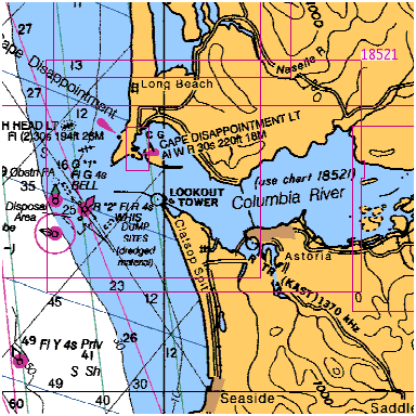
Ilwaco and the Ocean
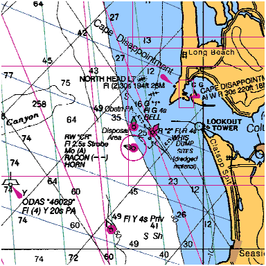 First things first: Tales of the Columbia River bar can be intimidating. If it makes you stop & think, then think again, with respect for this kind of water, then maybe you have gained some insight as to what can & does happen. This area around the mouth of the Columbia has been named “The Graveyard of the Pacific”. For a small boat, a 17′ or 19′ with a deep hull would probably be considered minimal. The well functioning “kicker”, or auxiliary motor of some kind would be mandatory in my book. If you watch the weather, time & tides & use sound judgment there, you should be able to cross the bar.
Getting there: We will use Ilwaco as our departure point. Ilwaco has two launches, one double ramp & a sling run by the port, & the other ramp at the Fort Canby State Park. There is another launch & sling at Chinook on the Washington side & then Warrenton & Hammond on the Oregon shore are also used. It just depends on where you are coming from.
Boat Launches
There are many launches on both the Washington & Oregon side of the river in this vicinity.
- Ilwaco: Port of Ilwaco 165 Howerton Ave., Ilwaco, WA 98624, 360-642-3143
- Fort Canby (State Park)
- Chinook: Port of Chinook, 1 Portland St., Chinook, WA 98614, 360-777-8797
- Hammond: Hammond Marina, 1099 Iredale St., Hammond, OR 97121, 503-861-319
- Warrenton: Warrenton Marina, 550 NE Harbor Pl., Warrenton, OR 97146, 503-861-3822, harbormaster’s cell 503-791-1925
- Skipanon Marina: Skipanon Marina, 200 NE Skipanon Drive, Warrenton, OR 97146, 503-861-0362
- Youngs Bay Yacht Club: Youngs Bay Park, Astoria, OR, 503-325-7275
The launch at Ilwaco is off the main road into town just after you drop down off the hill, take a left at the sign that says launching ramp. If you miss that, then just go a few blocks to the stop light, turn left and the frontage road at the dock area, follow it back to the eastern end & then south around the boat basin to the launch on the south east side. There is a nice new two lane ramp, also a sling, & with lots of paved parking.
For Fort Canby, you have to go east thru the town of Illwaco, at the stop light, west & south & then back east, winding thru the park then down to the ramp. The State Parks is planning to improve this launch in the early summer of 2003. The plans are to install a 3rd lane & to increase parking.
The Chinook launch is off Portland Street. It has a new concrete ramp and a sling, but parking is limited & the overflow is along the streets. Also the channel out of the Chinook harbor is narrow & somewhat winding on a LOW tide. There are however small hemlock poles pushed into the edge of the channel.
Bait:
Bait is available at both Ilwaco or Chinook thru Ed’s Bait. The Ilwaco location is on a dock that is close to the launch area. If you are planning on picking fresh bait up at the dock, they open at 5:00am. The Chinook location is out of a small grocery store on the west side of the main road north of the launch road. Fresh bait can be reserved at the Chinook Country Store, phone 360-777-2248, before closing time (around 7:30pm) the day before you need it. During the rush season, phone in as early as possible.
One recommendation is if you call the order in, is to have the person taking the order to read it back to you, specifically your name, the quantity and the DATE WANTED, if you need it for any date other than the next day.
Weather:
At the start of the normal salmon seasons, (usually the end of June) the weather may still be somewhat unpredictable. If you are a week-end sport fisherperson like most of us, you can expect to stay on the beach a few days because of bad weather. As the season progresses, the weather tends to stabilize up to September or so, but the ocean salmon seasons are ended by then & the Buoy 10 season will be in full swing. Here it can be foggy all day offshore, but it will usually be clear during the regular salmon season on shore. The wind if there is any, will be coming from offshore & usually from the northwest, but can vary to from the southwest. If you are trolling, after the wind picks up in the afternoon, it can get hard to control the boat unless you put the wind on your stern. The wind will, on many days pick up & be up to 15mph about 1:00pm to 2:00pm, then later in the evening around 7:00pm it will slow down again.
If the ocean is rough enough for the Coast Guard to close the bar during the regular salmon season, you might as well not even think about going fishing, as there are not many boat bottom fishing spots inside the jetties & the sturgeon season will be closed in the estuary by then. The season east of #10 does not open for salmon until August 1. About the only thing then is crabbing.
Heading Out:
Leaving the Illwaco boat basin from the launch, you will have head westerly toward the cannery buildings. Stay in the channel with Sand Island on your left. You will pass the boat launch at Fort Canby State Park on your right. There is a row of piling as a protective breakwater between the channel & the launch. Slightly farther south you will pass the Coast Guard Station, which is on your right. There is a sign here indicating NO WAKE as you pass their moored boats. Follow the channel south & you will come to breakwater pilings as you enter the Columbia River itself. If the tide & current are moving, you will have a turbulence here for a short distance. You are now in the main river. Make a right hand turn & head west out into the main river.
The closest buoy will be #11, (N46°15’75”, W124°02’15”) on your right, head toward it. From there, head southwesterly to buoy #10, (N46°15’32”, W123°03’75”). Follow the red buoy line out, with #8 being your next pickup point. If you are going to encounter any roughness it will be at about this #8 buoy to beyond #6, (N46°14’35”, W124°05’86”) which is about a half a mile. From #6 you want to head toward #4, but depending on the currents & roughness off the old submerged jetty, which has a buoy #2SJ, you may have to hold slightly outside of. When you get beyond the old jetty turbulence, you then can head to the east side of #4. You should be beyond any turbulence about half way to #4. The distance from #6 to #4 is slightly less than another half a mile.
 Do not try to cross the bar by following the “black”, or north buoy line as it is shallower & can be quite a bit rougher.
Crossing the Bar:
You have about a mile & half of bar condition waves to encounter. So it may be best for the newcomer to follow another partner boat out & back in a few times to learn the tricks. If you are new to this & even many “old-timers” would rather go out on the early part of the high or flood tide & then slide back in 3-4 hours later. The one thing that will get you in more trouble than any other thing is SPEED. This is not a boat race, hold your speed down if it is rough, and then cut the throttle as you ride over the a crest so that you do not slam the boat into a trough on the backside of a crest.
This river, like most rivers on the coast, you will need to be observant of the tides if operating a small boat. Tidal exchange is the key to crossing any bar. The experienced fishermen from here say the ideal time to cross is on high slack, or an hour or two each side of it. However the time of this tide many times does not allow you as a fisherman, to cross on one high tide & come back on the next high tide 12 hrs later during daylight hours. The word from many who fish it regularly is to NOT to try to cross on a low, or ebb tide as there is quite a bit of turbulence.
There is a formula that is used to calculate the amount of flow of a river flow at a bar. It is called the “rule of 12”. This flow will be best described as: For each our after the tide change the flow will be
1st hour will be 1/12th, 2nd hour will be 2/12ths,
3rd hour will be 3/12ths,
4th hour will be 3/12ths, 5th hour will be 2/12ths,
6th hour will be 1/12th
From this table you can see that the maximum flow will be the middle 2 hours of an exchange. This equates to the bar being roughest at that time. Wind conditions, on any tide, will extend these times. All else taken into consideration, the bar usually tends to not be as rough on the incoming tide. The tide exchange will govern how rough the bar is going to be. The low tides will have one real low tide each day & the other low tide will be somewhat higher. Look at the tide book & compare the difference between two tides closest to the time you intend to cross.
If any roughness is to be encountered, you will be able to see it better from inside looking out, as you can see the white water off the tops of the waves. Coming back in, you are looking at the backs of these waves & cannot see if there is any white water coming off the tops. Therefore the water looks calmer when you are outside looking in.
Heading back from outside:
You can visually run back the red buoy line, if you are close to it. Watching your water depth can also be a help because this region has no drop-offs, just a slight slope to the bottom until you get way out. Water depths at #4 & #6 are about 50′ with 90′ or so at #2., & 200′ at “CR”. Finding your way back may be somewhat helpful if you refer to your chart. “Don’t leave home without one”.
Crossing the bar coming back in:
This will be pretty much like going out, with the exception you will usually be riding in on a wave instead of heading into it. The situation can also be different if there is a tide & or wind involved where you will have to quarter the wave. You can be riding the back of a wave like a surfboarder but on the back side. It will run out from under you & the next one will have you surfboarding, many times at a angle. You will then have to straighten up the boat so that when you are being pushed into the trough of the next wave you are going straight with the wave. You do not want to be in the bottom of the trough at an angle. The most common thought seems to be “The boat will straighten up soon”. WRONG, you will need to power down somewhat. With the normal wave conditions here, you will normally be tipped to the starboard, your response should be to sharply steer to the starboard under mostly full power, so your stern is at a 90 degree angle with the oncoming wave. As soon as it passes under you, straighten out & get back on your heading again. Some boaters will get on the backside & have enough power to stay there & ride it all the way across. This can work, is a very smooth ride, but be aware that IF something goes wrong, it will happen VERY FAST, as these waves are usually doing in excess of 30 MPH.
GPS/Plotter
You should not even think about going out here without a GPS if you are the average week-end sport fisherperson. Acquire a GPS, learn how to use it and put in some locations to come home to. Here it can be foggy all day offshore, but will usually be clear during the regular salmon season on shore. Backtrack your red buoy line going out
Salmon Closure
There is a salmon closure at the mouth of the river called the Control Zone 1. This basically is all waters west of Buoy 10, between the north & south jetties, & inside of buoys #4 & #7. Refer to the WDFW regulations.
Salmon Locations:
The bulk of the salmon near the mouth will probably be Columbia River fish, with a few heading farther south. But many of the Oregon salmon south of the Columbia are Left Turning fish & they head south when they leave the rivers 2 or 3 years prior to returning. Any salmon will concentrate where the bait is, the best fishing will be where you find shrimp, which the herring will be feeding on. The salmon will be feeding on both.
A smart fisherperson may, when you catch the first salmon, cut its stomach open to see what it has been feeding on and try to match your bait to these stomach contents.
Many times, Chinook salmon can be found south of buoy #4 & farther south along the red buoy line. Don’t just run offshore because your buddy said that is where he caught his last weekend. Stop in and at least take a look or make a pass along the south buoy line before you make a long run to open water. If you see groups of whale birds sitting & diving, it may prove beneficial to stop & make a pass or two near them. With the fish in the top part of the water column, you will probably not be able to see them on your fishfinder.
Fish may be found where ever the bait is & straight west to 200′ can be productive. Most of the salmon fishing here however will be southwest of the mouth. Follow the south “red” buoy line out. There is no #2 buoy, & farther southwest is the “CR” or Columbia River buoy, N46°10’84” W124°01’50”, in about 200′ of water. The bulk of the salmon fishing will be from #4 to this old lightship buoy, or in that general area.
You will find the Coho from right on top to down 15-30′, however we have pulled some at 130′ later in the day. The Chinook will also be in the top water column if early in the morning or it is foggy. It would not be uncommon to catch them on a diver with from 20 to 30 pulls out. A pull is the distance from the reel face to the rod’s first guide, or about two feet. Later if or when the sun comes out the Chinook may decide to move down to from 50′ to the 100′ level.
Gear/Tackle:
About any salmon tackle can be used here, depending on your method. 8’6″ to 9′ medium fiberglass rods are the common size. Mooching was the method used by the charter boats to bring Westport to be the “Salmon Capitol of the World” in the 1950 & 60’s. The Columbia River charter boats followed. This method consists of using a 2 to 6 ounce (4 being the common size, kidney sinker tied to the terminal end of 25# monofilament mainline, & 6′ monofilament leader with a double hook, 3/0 4/0 mooching tie. These mooching leaders are usually 25# test & can be tied as a sold or a slip tie. The slip tied ones are usually used if you are using whole herring for bait. You can then thread the hooks into the bait & pull the rear one forward to put a bend in the bait to give it the proper roll. The solid tie leader is usually used if using a “cut plug” herring, as the angle on the bait gives the rolling action.
In the past 10 to 15 years, trolling with downriggers is probably the most popular with the average trailered sport boat. A 8’6″ downrigger rod is used here. They are a heavier but section up to about 1/2 way, with the tip a little stiffer than the mooching rods. These rods take a lot of strain when being pulled down against the clip on the wire. Ball weight will be from 12# to 15#. The ball depth will change depending on the specie of salmon targeted, & can range from 20′ to 150′. For Chinook, you may start out in the early morning or overcast days by only dropping it to 30′. However the usual target depth will be from 50′ to 70′. Later in the day you will probably have to go to 100′ to 120′. Bait can be cut plug herring, or herring in a bonnet, behind a Hot Spot flasher or a Fish Flash. These attractor colors will usually be green/glo for the Hot Spot, or quilted chrome, green, blue if for Chinook. You may change to red, if for Coho. Those who prefer to drag hardware will usually add behind the attractor, Coyote spoons in green/white glo, Cop Car, or Army Truck colors in 3.5″ & 4″ sizes. Apex plugs in chrome, mother of pearl, chrome/blue or Army Truck colors do very well in sizes 4.5″ or 5.5″.
Scent:
Of course you should add some Smelly Jelly in either herring or anchovy. Recently there has been a new twist for scent. That is “Salmon Scenter” by Salmon University. This is a receptacle that you place special nuggets inside & then snap it to your downrigger ball. This lays a scent trail better than Smelly Jelly can do.
Bottomfish Locations:
There are not any islands, very few uncharted rock reefs, and no kelp beds to attract bottom fish in this area. Some fishermen will bottomfish inside the South Jetty, or some of them will go out and then pull in behind and south (outside) the South Jetty, & fish for sea bass & lingcod. The main bottomfish location is usually south quite a ways and off Cannon Beach, Oregon, near the rock piles around Tillamook Head & south to Haystack Rock.
Crabbing Locations:
There is one thing to consider here if crabbing in the river, is that you need plenty of pot weights & lots of line out, as the currents will pull a single pot float under if you drop it off on a low tide & come back to pick it up on a high tide that has lots of exchange. You will come back and swear that someone has stolen your pot. But the float is just under water. You might have to come back next weekend at a low tide to try to retrieve it. However with the tidal currents, it may have been pushed even a couple hundred yards.
One old standby crabbing spot used is the inside of Baker Bay, behind Sand Island & north of the Chinook breakwater piling. The entrance here is between breakwater pilings #1 & #3. If can be shallow here at a low tide.
I would rather drop my pots in a more secluded place where everyone else doesn’t travel. But remember this river runs FAST & with a lot of FLOW, so pick your location carefully.
It has been mentioned to me by a RV business owner, that the pots with staffs & flags seem to stand out better & will be the ones pulled first by pot thieves. What they do when they pull your pot, they pull the line over one side of their boat & drop the float on the other side. They then handline the pot line up & over their boat, when the pot comes up they grab what they want & drop it back in the water. If you knew exactly where you dropped the pot & you find it moved about 100 yards, it is a pretty sure bet that it was pulled by one of these thieves, as that distance is about what it takes if the current or tide is moving them.
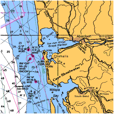
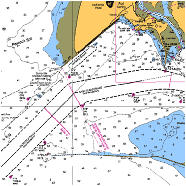
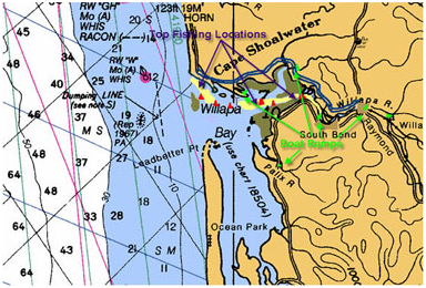
Willapa Bay
 This fishery season usually opens about the first of July, or when the adjacent ocean waters are open, but the main fish run does not really enter the bay until the middle of August or so. There can be a few “dip ins” into the mouth in the early season with a high incoming tide however. This river above Tokeland can be fished with a smaller boat, even a car-topper, if you watch the weather & stay, within reason, close enough to one of the many launches.
There are some large Chinook taken each year from these waters. This salmon fishery can be frustrating at times, as it can be hot & cold from one day to the other. You have to be there when the fish are. The people who seem to do fairly well here are the ones who put their time in. The catch ratio for hours fished, for some reason here is not as high, as say the Johns River fishery. You will encounter Coho & some Chum later on in the season.
There is also a commercial gill net fishery here:
So in this area, it may be best to check with WDFW at the Monesanto office as to when the netters are on the river. Be prepared for them to give you some days & dates for commercial areas that mean nothing to the sport fisherperson. Just trying to run from the South Bend launch downriver & have had to weave thru 35 net sets at low tide is not fun. If you are really determined to fish this river when the gillnets are in, it may be best to slide up the North River channel & out of their way. Some sport fishermen claim that for a few days after the nets come out, the sport catch drops off considerably.
Legally a net can not be laid across the complete river, but you may see one netter lay his from the north side to mid river & another netter lay his from the south side to mid river & they tie up to each other for a coffee/BS session in the middle. A recreational boater then will have to negotiate around the end of the net, usually in 2-3 feet of water if it is a low tide.
I have also seen floating dead sturgeon after these netters have pulled out.
Launches:
There are actually at least 8 launches that can be used in the Willapa Bay. These listed below are in sequence from starting at the lowest one on the river & then into the southern part of the bay.
- Tokeland, Port of Willapa Harbor
- Smith Creek WDFW
- South Bend
- Raymond City Park (not recommended for low tides, as it is shallow & MUDDY)
- Old Willapa / Wilson Creek WDFW
- Bay Center (this appears to be a private launch)
- Palix, WDFW
- Long Island, Willapa National Wildlife Refuge
Depending on what part of the bay you plan on fishing, you can consider any of these launches. For the normal fishery the preferable ones would probably be #1 & 3, they are closer to the action & do not require running thru a narrow channel, or longer distance.
The Tokeland Launch is owned by the Port of Willapa Harbor and a $5.00 fee is charged. The sport dock has moorage and the commercial docks are also available. There is plenty of parking here. A RV park is next to the parking area. In early 2000 the Port redid the ramp to include a 2-lane blacktop ramp with docks on both sides. They later dredged the whole boat basin. Now the concrete ramp extends down to -2′ with a bumper at the end of the concrete. The picture below was taken 7-02-04 at a -2′ LOW tide.
There is a boat ramp on the John’s River that is fine for smaller 18 ft boats and jet sleds. It’s located just past the Ocean Spray Company on the highway to Westport. For larger boats, use the ramp in Westport near the Coast Guard Station, it’s a short run back east to the John’s River.
The South Bend Launch is a good single lane concrete slab ramp with a moderate amount of parking. It is located on the main Highway just South & West of the town of South Bend. There is no fee for launching here. It is a fairly good ramp for boats up into the 20′ class. The ramp is concrete slabs & is angled out & downstream. Launching from this ramp will put you into the upper fishing area rather soon, as you will be running downriver & can be fishing at the big bend within 1 mile. The distance from this launch to Tokeland is about 8 miles.
Wilson Ceek Launch – This launch is reached by turning off Highway 6 at the old weigh station about a mile before you get to the hill coming into Raymond. Take a right just before the station, cross the next intersection, then take a right on the next road. This will take you up the river, across the bridge, thru the old town of Willapa & across the bridge at Wilson Creek. Turn left just across the bridge to the launch parking lot.
This area is fished by small boats after the fish have left the bay. The river here is still effected by tide. This area is not affected that much by floating debris. Many troll here with spinners, or plunk fish with a bobber & eggs.
Where to Fish
We will start with the main fishery in the Willapa itself. For many years the place to fish was to troll the beach in 10′ of water along “Washaway Beach”, just inside the main channel mouth on the North shore of the river. Over the years the ocean/river washed away about a mile of beach, including houses & the old Coast Guard lighthouse.
About 1998 the Army Corp of Engineers placed a short rock jetty at the upstream section that used to be the fishing area. This jetty has done what it was supposed to do, in that the beach is not washing away as it was before. It is a sight to walk the beach here at low tide & count the 1 1/2″ to 2″ pipes standing a few feet out of the water in line with the washed out roads. These pipes are what is left of the homes in the areas wells.
If you drive the Highway 105 & stop at this rock jetty during a mid outgoing tide, look off the end of the jetty, you will notice a rather swift section of water. Since this jetty has been installed most of the fishing has shifted upriver. As the shallower water near the beach has become deeper. My belief is that this jetty has raised the water speed & or turbulence to the point that the bait does not stay there in the concentrations that it used to. Some diehards still fish this area, but now generally nearer the NW point, near the ocean’s beach southern end & occasionally with good results.
Also do not use the previous Hunting & Fishing News illustrated map. The shaded area they list as motor mooching is really tide flats at low tide (MUD). The Western end of the river channel runs from south of Toke Point to the upriver Range Point on the East. You will see the range marker on this upriver bend, don’t try to drift to much north of these markers.
Most of the fishing that currently takes place is near the North River mouth, East of Tokeland about 3 miles, from marker piling # 7 to below the South Bend launch at #26 & usually takes place like most estuary fishing on the incoming tide. Marker #10 would be the entrance to North River. Marker #19 to #22 is in the upper of this location & seems to be a preferred location for some.
Low tide can be productive, in that the bay’s water has shrunk considerably at this location and therefore concentrates the fish that have moved in, but not migrated upriver yet.
Don’t just follow the concentration of boats thinking that is the “place to fish”, as that may not be the only fishy area in the bay. Most all the non-locals think the other guy is the expert. I was fishing there alone in 2001 near #26, with one other boat, while the whole flotilla was downstream from us a few miles. The other lone fisherman was using a electric trolling motor and the tide was almost all the way out. His larger outboard motor would not start. I offered to tow him back the ramp. He refused saying that he had a spare battery & that when the tide changed & started coming back in his electric would get him back to the ramp. But he confided in me that his main reason was that for the last 2 days he had pulled his limit of Chinook out of that area while everyone else was downriver, and we were alone there.
Like anywhere else a good pair of binoculars & you being observant, may help put fish in the box.
The one bad thing this time of the year, is at a high tide you will usually be confronted with floating grass on the water.
What to use and Methods
Most bay fishermen here use large herring that are cut-plugged & are trolled at a fast spin. It seems that the fresh bright fish will take about any salmon lure, but the fish that have moved in, but not went upstream because of lack of rain, need to have a very active lure pulled right in their faces.
Most trolled herring here will be behind a Fish Flash, & it is my belief that a short (36″) leader is in order because of the murky colored water. You can also try trolling a sardine wrapped Kwik Fish. Some of the locals just troll a large brass spinner. So try what you are comfortable with.
Crabbing can also be productive in the lower sections here.
Lower Willapa Bay
I have seen bait so thick in the main channel off what used to be Deadmans Island, that if you had a long handled net you could have gotten all the bait you would need for the next year. Usually where there is bait, there are also salmon. This time there was so much bait that our lures simply got lost in the crowd. I have also caught fish in the outside the main channel, but crossing the bar can be dangerous for a small boat. As just outside the point of land, the channel angles off to the Southwest & somewhat parallels the breakers. Recent reports are the bar’s channel has changed to where at a low tide the depth is less than 20′. If you have a wind & tide running, it is best that the small boater remain inside.
“South Channel”, which is a 50-60′ deep large area just south of Deadmans Island & north of Leadbetter Point. This is more protected than the main Willapa channel which can have a severe current at the outgoing tide. There are no buoys or markers on this “south side”. This channel shallows up considerably as it nears the ocean & breakers can be on the outside. It is not recommended crossing here to the open ocean, unless you do it at a high tide & then take a GPS reading from the inside so you know where to come back across at, as the breakers all look alike from the outside & you will not know where this channel should be. Not really recommended however.
As of the summer of 2000, Deadmans Island has pretty much been washed away after the installation of the rock jetty downstream a couple of miles. This may improve fishing somewhat from the standpoint that there was a colony of seals living on this island. 2002 & 2003 saw some of the island visible at low tide, however, but apparently not enough for the seals to return to.
Middle Section of the Bay
If you fish this area following the pattern of the other fishermen who appear to “know” what to do & where to go, you may well come home skunked at times. If you read some back issues of Salmon-Trout-Steelheader, and take a bit of information out of each article, some light begins to glimmer.
One article by Nick Amato in Oct-Nov 1998 entitled Trolling Tiderwater With Spinners, he talks about trolling the lower tidal rivers for Chinook. The one thing that can be gotten from this is that he recommended using a electric trolling motor. At first thought, it was just for a more controlled slow speed. But also if you watch some of the guides on the larger rivers, they will many times also use this method. What this information may point to, is that in the shallower confined water the use of a regular outboard trolling motor is very possibly spooking the fish. Taken this into consideration the many other boats in the area, I think the fish DO get spooked.
Now in addition to this if you look in the same issue an article by Gary Siegel has an article entitled Fall Runs In Low Water. This article is geared mainly for the upper reaches of tidewater, but there are a couple of paragraphs at the end that brought this spooked fish back to mind. Here they were catching nothing on the lower Chehalis, like all the other fishermen that day, even though the fish were jumping, they finally moved into a area close to some pilings that they had seen fish jumping. While his partners used spinners, he put on a steelhead jig & cast into the logs, they came up with 3 fish before loosing the jig. This reinforces somewhat the idea that salmon tend to “hide” along shore, near piling, logs, etc. & at a deeper depth than the thought, when the boating traffic increases.
If you fish the bays enough, you will experience somewhat the same experience, with Coho jumping within 5 feet of shore at low tide in less than 2 feet of water, while everyone is trolling the main channel. There are no piling or protective brush here, but they must may feel more secure than in deeper water that everyone is crowded into. Here the fish seem to be moving upstream in small schools. If you see a school of finning or jumping Coho, they will be moving upstream. Follow them, or run on the other side of the river to avoid them & then go above them hoping to intercept then again.
North River
empties into the bay at marker #10, closer to Tokeland and between Southbend. The lower section of this river itself from the big bend to the Hiway 105 bridge can be productive. The channel is narrow & SHALLOW for the first 1/4 mile from the Willapa marker piling #10, then upriver it opens up slightly at low water. This is a situation where the Smith Creek launch can be utilized. However a larger boat can not get under the low Smith Creek Hiway 105 bridge at a high tide to get the 100 yards needed to enter into North River. There is a private hatchery program on this river that releases a considerable number of Chinook, Coho & Chum salmon into this river every year. The WFDW does not make this information readily available.
Season limits for North River from the Hiway 105 bridge to Salmon Creek is open to salmon fishing from Sept. 1 to Nov. 30 with a liberal total limit of 6 salmon. There are numerous houseboats tied to pilings in this lower stretch of river. There is a good section of boat fishable water above the bridge for about 3 or 4 miles upstream to the end of tidewater at about Float House #29. At a low, 0.0 tide you may encounter only 2′ of water at this upstream location.
One method of fishing this upper extreme spot is to get there just before low tide change. Stop in the middle of the river, but do not anchor, & simply cast spinners using a spinning outfit & 15# monofilament mainline. If the fish are there, they will be jumping or rolling occasionally. Use a Metric #5 spinner & ahead of it about 20″, place a 3/8 oz. beadchain keel sinker. There are plenty of underwater limbs & snags in this area. This sinker helps you cast farther & keeps the lure near the bottom, plus it runs interference for the spinner’s single point hook & lessens possible hang ups. Keep casting, as the tide turns & comes back in, the fish seem to drift upstream past you. Just because you see the fish jumping or rolling, do not be duped into thinking they are on the top of the water. This water is shallow & you need to fish the lure NEAR the bottom.
Upriver Willapa
Later in the season after the fish move upstream, you may consider moving upstream with them. Here is where the Raymond City Park launch or the Old Willapa Camp One / Wilson Creek launch come into play. Fishing from the Old Willapa area you will be in the final tidewater area of the river. Usually large spinners are used here either trolled or cast. Here is where trolling the brush line will pay off during high tide. Then at low tide, casting into the holes can also prove productive.
Naselle River
The Naselle can produce salmon also, the closest launch in tidewater is the Long Island Game Refuge ramp. This is a no charge gravel launch wide enough for 2 boats, no dock & parking is across the road by the office. Launch here & head north, staying close to the piling markers on the east side of the channel most of the way out, as this channel is also narrow, shallow & is covered with oyster beds. I have however navigated it with a 20′ fiberglas deep Vee at a 0′ tide. You can make it if you go slow & are willing to back up & try another spot until you learn the channel. You may only have 3′ of water under you at times. When the piling markers on the right side of the channel cease & you get to where the channel opens up, you will see a clay bank bluff on the western shore of Long Island ahead of you, head angling across the channel toward this bluff, then follow this shore until you come out into the mouth of Long Island & Stanley Peninsula where you take a right at the piling marker & to the east & head up the main Naselle River.
There is also a small gravel launch on the East side of the Hiway Southwest of the town of Naselle that is good for only smaller sleds or drift boats. This is also a river that can be fished like the upriver Willapa.
Palix River
Here is where the Palix WDFW or Bay Center launches can be utilized. This is a smaller shorter river, but does have fish in it. The upper section of this river will be only fishable from the bank.
Nemaha River
This river has no launch & is best fished from the bank.
How to Fish for Salmon | How to Catch Salmon | How to Fish for Tuna | How to Catch Tuna | How to Fish for Halibut | How to Catch Halibut